


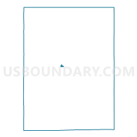
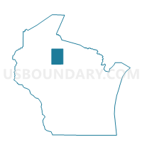
Phillips - C 2 Voting District, Price County, Wisconsin
About
Outline

Summary
| Unique Area Identifier | 696331 |
| Name | Phillips - C 2 Voting District |
| County | Price County |
| State | Wisconsin |
| Area (square miles) | 0.33 |
| Land Area (square miles) | 0.33 |
| Water Area (square miles) | 0.00 |
| % of Land Area | 100.00 |
| % of Water Area | 0.00 |
| Latitude of the Internal Point | 45.69490250 |
| Longtitude of the Internal Point | -90.41040070 |
Maps

Graphs
Select a template below for downloading or customizing gragh for Phillips - C 2 Voting District, Price County, Wisconsin


Neighbors
Neighoring Voting District (by Name) Neighboring Voting District on the Map
- ELK - T 2 Voting District, Price County, WI
- Phillips - C 1 Voting District, Price County, WI
- Phillips - C 3 Voting District, Price County, WI
- Phillips - C 4 Voting District, Price County, WI
- Phillips - C 5 Voting District, Price County, WI
- WORCESTER - T 1 Voting District, Price County, WI
Top 10 Neighboring County Subdivision (by Population) Neighboring County Subdivision on the Map
- Worcester town, Price County, WI (1,555)
- Phillips city, Price County, WI (1,478)
- Elk town, Price County, WI (988)